• This is a political forum that is non-biased/non-partisan and treats every person's position on topics equally. This debate forum is not aligned to any political party. In today's politics, many ideas are split between and even within all the political parties. Often we find ourselves agreeing on one platform but some topics break our mold. We are here to discuss them in a civil political debate. If this is your first visit to our political forums, be sure to check out the RULES. Registering for debate politics is necessary before posting. Register today to participate - it's free!

Pennsylvania strikes a blow against gerrymandering distticts

Dittohead not!

master political analyst
DP Veteran
Joined
Dec 3, 2009
Messages
52,046
Reaction score
34,013
Location
The Golden State
Gender
Male
Political Leaning
Independent
[h=1]Pennsylvania Supreme Court Strikes Down State's Congressional Map, Saying It Illegally Benefits GOP[/h]
The Pennsylvania Supreme Court on Monday ruled that the state’s congressional map went so far to benefit Republicans that it “clearly, plainly and palpably” violated the state constitution.

Seems to me that there are a lot of congressional maps that benefit either Republicans or Democrats "clearly, plainly, and palpably," and need to be re drawn by a non partisan entity so as to make elections more fair and congressional seats less secure.
 
I wonder how we could implement an unbiased way of drawing the lines... because everyone knows what would benefit who...
 
Seems to me that there are a lot of congressional maps that benefit either Republicans or Democrats "clearly, plainly, and palpably," and need to be re drawn by a non partisan entity so as to make elections more fair and congressional seats less secure.

Everyone seems to say that, but what's the formula?
 
Everyone seems to say that, but what's the formula?
I think, a north/south line moving west, when the strip hit the right population, that's a district.
You could also have a east/west line moving north or south.
I think straight lines would make our representatives have a wider range of constituents.
 
So . . . what's the formula? You can't create this computer program without it.

A random grouping of population segments would work fine. These gerrymandered maps weren't mistakenly drawn. They used computer software and consulting firms to draw these maps in order to maximize their political power.
 
Program a computer to make districts as diverse as possible.

OK. Seriously, how is one supposed to "diversify" a place like LA County or San Francisco? You'd have to bus Republicans in just to get to 10%. Here in Tucson we've got precincts that lean 80% Democrat. You can't fix that without forcing people to move.
 
I wonder how we could implement an unbiased way of drawing the lines... because everyone knows what would benefit who...

See Iowas method. You will find it interesting. Very little human input.
 
It has to be done geographically. How do you go about this?

The same way they've created software that purposely creates lines geographically to Gerrymander the districts. It's already being done but taking into account voting patterns and using that data to create as many districts as possible that support one party over another.

https://www.washingtonpost.com/news...ithout-gerrymandering/?utm_term=.d0ad6a7029ec

As pointed out in the article, the algorithm to create non-gerrymandered optimally compact equal population districts is more straightforward than what these current consultants use.

Story is behind a paywall. What's the algorithm? And what represents a "non-gerrymandered optimally compact equal protection district"? How do you know when you have one?
 
Program a computer to make districts as diverse as possible.

Except, 'gerrymandering' on behalf of parties, including on behalf of party "balance", is still manipulating based on political affiliation. While I admit that "balancing" has an appeal (just as admitting new immigrants, based on balancing their party politics has an appeal) I don't know that it is right.

I would rather see districts based on communities of mutual interest; representing a random block of people who have no sense of community or mutual interest only gives politicians the latitude to fail to represent some portion of his constituents.

Urban, suburban, rural, and small towns all have different communities of interest - as do different economic and racial areas. Districts should represent those areas and their politicians should act in their interest accordingly.

It is complete nonsense to have districts wherein natural and sociological boundaries are meaningless.
 
The same way they've created software that purposely creates lines geographically to Gerrymander the districts. It's already being done but taking into account voting patterns and using that data to create as many districts as possible that support one party over another.

https://www.washingtonpost.com/news...ithout-gerrymandering/?utm_term=.d0ad6a7029ec

As pointed out in the article, the algorithm to create non-gerrymandered optimally compact equal population districts is more straightforward than what these current consultants use.

For two or three decades (at least) I have proposed minimum bounded districts and till now, I didn't know there were "optimally compact" algorithms ( no doubt an idea stolen from me ;) ). However, in the last few years I have changed my mind.

The boundary of a district is less important that what he district should be representing, i.e.; a community of mutual interest. I can't think of anything more disenfranchising than taking a slice of a minority urban community and tossing it into a largely rural white district.

Be reminded, the American political system was supposed to represent people, not party's. Citizens elected representatives to represent THEM in Washington, not parties in Washington. Loading the system on behalf of the two major parties does not support that vision.
 
The same way they've created software that purposely creates lines geographically to Gerrymander the districts. It's already being done but taking into account voting patterns and using that data to create as many districts as possible that support one party over another.

https://www.washingtonpost.com/news...ithout-gerrymandering/?utm_term=.d0ad6a7029ec

As pointed out in the article, the algorithm to create non-gerrymandered optimally compact equal population districts is more straightforward than what these current consultants use.

I didn't have a problem with a paywall to your link.
It's obvious the independent maps strive to have as much of a rectangular shape as possible, with the least perimeter around the area ...
 
What is it?

Iowa lost a CD in 2010, going down to 4.
This reminds us of gains and losses of CDs in states based on the already contentious Census.

Iowa basically divided the state into 4 corners, with 3 of their CDs considered swing this year, a good thing imo.
The northwest CD of steve king is rated R + 11.

It's easy to draw these CDs when there aren't huge population centers.
None of what I'm reading on DP even addresses the Majority-Minority CDs.

The goal is to get rectangular shapes for districts, with the smallest possible perimeter of said 700,000 plus people.

Anyone looking at the 7th CD in Pennsylvania recognizes its creativity, octopus like, with a ridiculous perimeter.
One thing's for sure, Americans are more aware of the 142 remaps up in 2021 ...
 
Story is behind a paywall. What's the algorithm? And what represents a "non-gerrymandered optimally compact equal protection district"? How do you know when you have one?

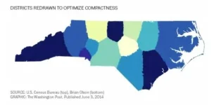
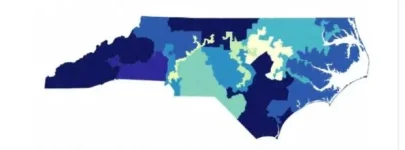
The algorithm was written by a software engineer in his spare time. The program takes basic census blocks and creates equal voting districts using it. Below are a couple of picture using North Carolina to show how different they look. The top is the gerrymandered districts where squiggly district lines spread throughout the state in order to group people. The bottom is and example of compactness.

Old.webpNew.webp
 
The algorithm was written by a software engineer in his spare time. The program takes basic census blocks and creates equal voting districts using it. Below are a couple of picture using North Carolina to show how different they look. The top is the gerrymandered districts where squiggly district lines spread throughout the state in order to group people. The bottom is and example of compactness.

View attachment 67227520View attachment 67227521

OK, but how do we know those districts are "fair"? I'm currently in one of them; I see a few potential problems. The southeastern dark blue district could easily be claimed to be gerrymandered against Democrats, given all the Republicans on the coast and the Democrats inland.

Look, what I'm looking for is an above-board definition of what constitutes a "fair" district, and an above-board method of drawing the map according to that definition.
 
For two or three decades (at least) I have proposed minimum bounded districts and till now, I didn't know there were "optimally compact" algorithms ( no doubt an idea stolen from me ;) ). However, in the last few years I have changed my mind.

The boundary of a district is less important that what he district should be representing, i.e.; a community of mutual interest. I can't think of anything more disenfranchising than taking a slice of a minority urban community and tossing it into a largely rural white district.

Be reminded, the American political system was supposed to represent people, not party's. Citizens elected representatives to represent THEM in Washington, not parties in Washington. Loading the system on behalf of the two major parties does not support that vision.

I can see that point of view, but what is the larger problem...a party building in an advantage or the need to group similar people into a district? The Wisconsin example used in the recent Supreme Court case is pretty remarkable. Slim majorities in votes turns into super majority and actually losing the elections resulting in a majority. That's pretty disenfranchising as well, not to mention it's very undemocratic.
 
OK, but how do we know those districts are "fair"? I'm currently in one of them; I see a few potential problems. The southeastern dark blue district could easily be claimed to be gerrymandered against Democrats, given all the Republicans on the coast and the Democrats inland.

Look, what I'm looking for is an above-board definition of what constitutes a "fair" district, and an above-board method of drawing the map according to that definition.

Anti-Gerrymandering isn't the idea that every district would be a competitive district. If a district is dominated by Republicans or Democrats because the area tends to vote that way, then that's working as intended. The gerrymandered districts above that are purposely drawn to create artificial super majorities of a party in few districts. The other districts are drawn so that the party drawing the boundries has 55-60% majority. A gerrymandered states will usually have a few + high numbered districts of one party, and a lot more + lower number districts for another party.

The goal is to pack as many of one party into the fewest number of districts. As long as the districts are compact and the basis of how they were drawn is transparent and available to anyone, that's fair.

Why is that the goal? That just seems like a different kind of gerrymandering. I would think the goal ought to be entirely non-partisan.
 
I can see that point of view, but what is the larger problem...a party building in an advantage or the need to group similar people into a district? The Wisconsin example used in the recent Supreme Court case is pretty remarkable. Slim majorities in votes turns into super majority and actually losing the elections resulting in a majority. That's pretty disenfranchising as well, not to mention it's very undemocratic.

Democrats win the total House of Delegates vote in Virginia by 10 points and still come up short.
It's not just the 43 federal remaps either; it's also the 99 state chamber remaps; with the state chambers doing all 142.

I consider REDMAP 2010 by GOP architect Chris Jankowski to be the most brilliant electioneering I've seen, and I first voted in 1972.
He gave a lengthy interview to Rachel Maddow a few years ago on his model, and frankly, DEMs have copied it.

So, all hands on deck with the Holder/Obama redistricting project to oppose REDMAP 2020 ...
 
Typo, the goal of Gerrymandering is to pack as many of one party into the fewest amount of districts.

Then what is the goal of "fair" districting?
 
Back
Top Bottom