• This is a political forum that is non-biased/non-partisan and treats every person's position on topics equally. This debate forum is not aligned to any political party. In today's politics, many ideas are split between and even within all the political parties. Often we find ourselves agreeing on one platform but some topics break our mold. We are here to discuss them in a civil political debate. If this is your first visit to our political forums, be sure to check out the RULES. Registering for debate politics is necessary before posting. Register today to participate - it's free!

[Alaska] 37-Vehicle Collision

Glitch

DP Veteran
Joined
Apr 3, 2019
Messages
22,341
Reaction score
9,893
Location
Alaska (61.5°N, -149°W)
Gender
Male
Political Leaning
Conservative
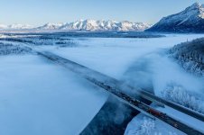
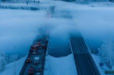
PALMER — A massive pileup in dense fog and frigid cold closed the Glenn Highway in both directions for several hours Thursday at the Knik River bridges in Mat-Su.

Alaska State Troopers said the chain-reaction collision involved 37 vehicles. The line of traffic skidded to a stop on the southbound bridge violently enough to injure more than a dozen people in cars, pickups, and at least two semis. Authorities and drivers described slick road surfaces with extremely limited visibility.

No life-threatening injuries were reported, said Ken Barkley, emergency services director with the Matanuska-Susitna Borough. Barkley said 13 people required medical transport from the scene — nine by borough ambulances and four by either Chugiak Volunteer Fire and Rescue or the Anchorage Fire Department. It wasn’t clear how many other people reported more minor injuries.


FenderBender0.jpg
FenderBender1.jpg

It should be noted that the Glenn Highway is the only way into, or out of, Anchorage northbound. You can enter or leave Anchorage in only one of two ways via the road, to the northeast or to the south. They were lucky this time. Traffic was only stopped for an hour and a half. I have been on the Glenn Highway when it was closed for more than six hours clearing accidents. I left work at 5:00 PM and didn't get home until 11:00 PM. Thankfully, that was during the Summer, so I did not have to endure the -20°F these people had to endure.

Had the "Bridge to Nowhere" been allowed to be built in 2008, it would have connected Anchorage with the Matanuska-Sustina Valley at Point MacKenzie, providing a second northbound access from Anchorage. Approximately 30,000 commuters travel the Glenn Highway from the Matanuska-Sustina Valley into Anchorage on a daily basis.
 

View attachment 67489423
View attachment 67489424

It should be noted that the Glenn Highway is the only way into, or out of, Anchorage northbound. You can enter or leave Anchorage in only one of two ways via the road, to the northeast or to the south. They were lucky this time. Traffic was only stopped for an hour and a half. I have been on the Glenn Highway when it was closed for more than six hours clearing accidents. I left work at 5:00 PM and didn't get home until 11:00 PM. Thankfully, that was during the Summer, so I did not have to endure the -20°F these people had to endure.

Had the "Bridge to Nowhere" been allowed to be built in 2008, it would have connected Anchorage with the Matanuska-Sustina Valley at Point MacKenzie, providing a second northbound access from Anchorage. Approximately 30,000 commuters travel the Glenn Highway from the Matanuska-Sustina Valley into Anchorage on a daily basis.

This occasionally happens leaving my city in a direction around a large body of water. It occurs on the interstate, and through snow. As wind comes off the water it sets up a snow machine that simply cannot be kept-up with on the interstate.

Passengers have been trapped for as long as 18-20 hours. If they run out of gas, their lives become endangered. There's simply no way to get to them in the deep snow, if the line of trapped vehicles extends for 15-20 miles.

--

That's amazing looking territory in that image!
Fog is always really bad at the Knik River bridge. As you can tell from the photos, the sun is up but the bridge is still covered in shadow from the Chugach mountain range in the south, and not included in the photo. The mountain range in the background of the first photo is the Talkeetna mountain range. Matanuska Valley is sandwiched between the Talkneetna range to the north and the Chugach range to the south. The Matanuska River and the Knik River flow into the Knik Arm of Cook Inlet, and merge where the Knik River bridge is located.

NOTE: "Knik" is a name that originates with the Kluti-Kaah native tribe in Alaska, and neither "k" is silent. It is pronounced: Kuh-Nik.

The territory looks beautiful, Glitch.

I remember hearing a quote from a lower 48 worker, who worked on building the Alaskan Highway:

"Miles and miles of nothing but miles and miles!"

I heard that quote decades ago, and loved it.
 
If it's unsafe to drive at any speed, then you shouldn't drive. Take a day off work, miss a date, whatever, but don't lean on more responsible people by claiming your damages from insurance. Idiots.
 
The territory looks beautiful, Glitch.

I remember hearing a quote from a lower 48 worker, who worked on building the Alaskan Highway:

"Miles and miles of nothing but miles and miles!"

I heard that quote decades ago, and loved it.
Winter is the second prettiest season in Alaska, after Autumn. It is also the only time of the year when Alaskans get to enjoy their own State. During the Summer Alaska's population more than triples in size with 2.1 million tourists.

It is too bad they didn't include a photo of Pioneer's Peak, the view everyone has of the Chugach mountains as they drive into Anchorage. This is what everyone sees when driving south bound into Anchorage:
1706382452460.jpeg

During the Winter the sun is only 15° above the southern horizon, and it rises (well after 10:00 AM) right behind Pioneer Peak. The shadow you saw in the photos above were created by Pioneer Peak.
 
If it's unsafe to drive at any speed, then you shouldn't drive. Take a day off work, miss a date, whatever, but don't lean on more responsible people by claiming your damages from insurance. Idiots.
Or one could learn to drive according to the conditions. The highway was fine. Clear of any snow and ice on a perfectly clear sunny day. Then you reach the Knik River Bridge, which was completely covered in thick fog and unbeknownst to you, the bridge is experiencing icy conditions. All you see is a wall of white fog ahead. No signs of any accidents or trouble of any kind.

Do you continue driving like you have been? Or do you slow down to the point where you can actually see what is in front of you, even if it means coming to a complete stop, once you reach the fog? Or do you follow your advice, turn around and just go home?

Those who are afraid/unable to drive in adverse conditions do a lot of walking and get nowhere in Alaska.
 
Best wishes for a full recovery for everyone involved. I hate traffic accidents. It's a big fear of mine.
 
I can't wait to get back out to Wyoming, sometime.

But, Alaska looks like Wyoming on steroids!
 
I can't wait to get back out to Wyoming, sometime.

But, Alaska looks like Wyoming on steroids!
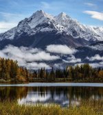
Glacier National Park in Montana is about as close as you can get to what Alaska looks like in the lower-48. The foliage is completely different, of course, but the terrain and the wildlife are similar. This is what I see from my backyard during the Summer:

Alaska Range.jpg

Like Alaska, it can snow in July in Montana if you are at elevation. There are even a few glaciers left in Glacier National Park, although they are melting quickly. Alaska still has 27,000+ glaciers, with some of them advancing and not retreating. All the grizzlies in Montana, however, are inland grizzlies. Meaning they are much smaller (less than half the size) of an Alaskan brown bear. Montana also has Big Horn sheep hanging out along the continental divide, which are similar to Alaska's Dall sheep. So there are a lot of similarities.
 
Back
Top Bottom