• This is a political forum that is non-biased/non-partisan and treats every person's position on topics equally. This debate forum is not aligned to any political party. In today's politics, many ideas are split between and even within all the political parties. Often we find ourselves agreeing on one platform but some topics break our mold. We are here to discuss them in a civil political debate. If this is your first visit to our political forums, be sure to check out the RULES. Registering for debate politics is necessary before posting. Register today to participate - it's free!

American spy plane pilots use China’s satellite navigation system BeiDou as backup to GPS, US genera

JacksinPA

Supporting Member
DP Veteran
Monthly Donator
Joined
Dec 3, 2017
Messages
26,290
Reaction score
16,771
Gender
Male
Political Leaning
Progressive
American spy plane pilots use China’s satellite navigation system Beidou as backup to GPS, US general says | South China Morning Post

Pilots of U-2 ‘Dragon Lady’ reconnaissance aircraft have a receiver chip in their watches that allows them to access the Chinese, Russian and European positioning systems, US Air Combat Command Chief James Holmes says

Beidou went into commercial operation in 2018 and a third-generation service is expected to be up and running later this year


American spy plane pilots use China’s satellite navigation system as a backup to GPS on their missions, according to a US Air Force general.

The second generation of the Chinese system, known as BeiDou, began providing global services at the end of 2018 and a third phase, with more satellites, is expected to be fully functional later this year.
=======================================================
This ability is not just a backup. Our GPS satellites would be among the first targets to be hit in a Chinese strike.
 
Re: American spy plane pilots use China’s satellite navigation system BeiDou as backup to GPS, US

With tesla's billion satellites, it will become increasingly unlikely that anybody can take out enough at once to gain some military advantage.
 
Re: American spy plane pilots use China’s satellite navigation system BeiDou as backup to GPS, US

During the cold war the U-2 was called a spyplane while now it's called a "reconnaissance aircraft" ha. Whatever it's called and whenever the U-2 is a precious USA national security and defense asset of the first order.


Russian and Chinese Satellites Are Helping US Pilots Spy on Russia and China - Defense One

American U-2 spy plane pilots, who have long flown bleeding-edge technology to the edge of Earth’s atmosphere, have a new high-tech gadget: a watch that receives satellite navigation coordinates from Russian, Chinese, and European satellites.

While [Gen.] Holmes did not name the watch manufacturer, the Air Force purchased 100 Garmin D2 Charlie Navigation Watches back in February 2018.

“Designed with pilots of varying backgrounds and missions, the D2 Charlie Aviator Watch features a colorful, dynamic moving map which depicts airports, navaids, roads, bodies of water, cities and more, offering greater situational awareness,” the watchmaker said in a statement at the time.

Russian and Chinese Satellites Are Helping US Pilots Spy on Russia and China - Defense One
 
Re: American spy plane pilots use China’s satellite navigation system BeiDou as backup to GPS, US

American spy plane pilots use China’s satellite navigation system Beidou as backup to GPS, US general says | South China Morning Post

Pilots of U-2 ‘Dragon Lady’ reconnaissance aircraft have a receiver chip in their watches that allows them to access the Chinese, Russian and European positioning systems, US Air Combat Command Chief James Holmes says

Beidou went into commercial operation in 2018 and a third-generation service is expected to be up and running later this year


American spy plane pilots use China’s satellite navigation system as a backup to GPS on their missions, according to a US Air Force general.

The second generation of the Chinese system, known as BeiDou, began providing global services at the end of 2018 and a third phase, with more satellites, is expected to be fully functional later this year.
=======================================================
This ability is not just a backup. Our GPS satellites would be among the first targets to be hit in a Chinese strike.

It is simply being thorough.

GPS is not even the main navigation system that aircraft use. Their primary system is still inertial navigation, which uses no satellites at all. All of the GPS systems are simply redundancy to confirm the first is working properly. All of the GPS systems in the world can be knocked out, our aircraft will still get to where they need to go just fine without them.
 
Re: American spy plane pilots use China’s satellite navigation system BeiDou as backup to GPS, US

Inertial navigation tech has gotten so good it can deliver missiles within 30 meters from 1,000 miles away, let alone with terrain mapping. Our Ohio class SSBN's dont even use satellites for missile targeting and we can still put 8 mirv'ed Trident D5's into an infield from 4,600 miles away. Multi GPS tech is simply a redundancy, and a cheap one to boot. Besides GPS-lllM is extremely difficult to jam and its up and running now.
 
Re: American spy plane pilots use China’s satellite navigation system BeiDou as backup to GPS, US

It is simply being thorough.

GPS is not even the main navigation system that aircraft use. Their primary system is still inertial navigation, which uses no satellites at all. All of the GPS systems are simply redundancy to confirm the first is working properly. All of the GPS systems in the world can be knocked out, our aircraft will still get to where they need to go just fine without them.

Digital sextant.... ;)
 
Re: American spy plane pilots use China’s satellite navigation system BeiDou as backup to GPS, US

Digital sextant.... ;)

Sextants are still probably the most accurate way to find your position. The only downside is that they are not that great in a moving vehicle.

They are still our main way of positioning PATRIOT missiles and other military equipment, so long as you can find 2 or more fixed location landmarks they are highly accurate.

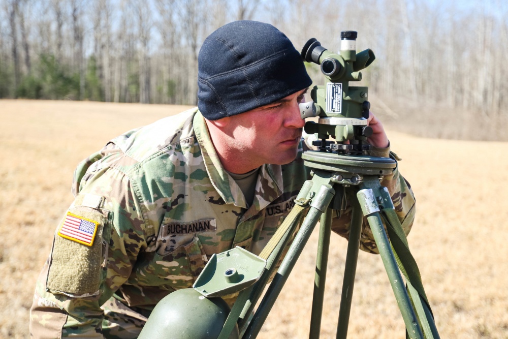
The way we place a PATRIOT system is still unchanged compared to how we did it 40 years ago. Plot the location on a map, then using a compass and map you confirm you are at the location. Then use a sextant you verify it yet again, normally bringing the accuracy down from say 50 meters to 10 meters. We then use an inertial navigation system to verify it yet again (strapped to the hood of a vehicle that drives around), then finally a GPS as a final check.

The only thing added since 1980 is the GPS part. But it does not matter, accurate to within 10 meters is more than accuracy enough for that system. By that point, we are mostly concerned with equipment being placed to close together (because of backblast).

But the sextant we use is actually the good old M2 Aiming Circle.

aiming-circle%2B12MAR17.jpg


Which is little changed from the M1 Aiming Circle used in WWII.

TM-9-1290-357-150011im.jpg
 
Re: American spy plane pilots use China’s satellite navigation system BeiDou as backup to GPS, US

It is simply being thorough.

GPS is not even the main navigation system that aircraft use. Their primary system is still inertial navigation, which uses no satellites at all. All of the GPS systems are simply redundancy to confirm the first is working properly. All of the GPS systems in the world can be knocked out, our aircraft will still get to where they need to go just fine without them.

I thought Dragonladies navigation was by stars similar to the system on the SR-71.
 
Re: American spy plane pilots use China’s satellite navigation system BeiDou as backup to GPS, US

American spy plane pilots use China’s satellite navigation system Beidou as backup to GPS, US general says | South China Morning Post

Pilots of U-2 ‘Dragon Lady’ reconnaissance aircraft have a receiver chip in their watches that allows them to access the Chinese, Russian and European positioning systems, US Air Combat Command Chief James Holmes says

Beidou went into commercial operation in 2018 and a third-generation service is expected to be up and running later this year


American spy plane pilots use China’s satellite navigation system as a backup to GPS on their missions, according to a US Air Force general.

The second generation of the Chinese system, known as BeiDou, began providing global services at the end of 2018 and a third phase, with more satellites, is expected to be fully functional later this year.
=======================================================
This ability is not just a backup. Our GPS satellites would be among the first targets to be hit in a Chinese strike.

China has no ability to strike GDP satellites. No one does. The only satellite intercepts that have ever occurred have happened at altitudes below 1,000km. GPS satellites orbit at altitudes of 20,000km.

They only way you could reliably destroy a satellite at that altitude is with nuclear weapons, and then, we're talking about the same altitudes that the US's nuclear launch detection satellites operate at, so there's no way to know the enemy was only targeting GPS and wasn't trying to blind us to a nuclear first strike, so the clear response to is launch a nuclear first strike of our own.
 
Last edited:
Re: American spy plane pilots use China’s satellite navigation system BeiDou as backup to GPS, US

China has no ability to strike GDP satellites. No one does. The only satellite intercepts that have ever occurred have happened at altitudes below 1,000km. GPS satellites orbit at altitudes of 20,000km.

Not quite true.

USA-193 was destroyed by an ASAT warhead, deployed by Delta II rocket. Now granted the satellite was a failure to launch and was at only a few hundred KM altitude, it is not like we are going to test such a system on a "real world" satellite. However, it was launched on the exact same rocket that is used to launch similar satellites, and is capable of reaching those altitudes.

We are not about to use an actual ASAT weapon on a test on a working bird, and then risk future launches to replace it with having to deal with debris from the first bird. Might as well deploy a destroyer into a region where one had already hit a mine, in the belief that since one had already been hit, there was no longer a risk.

Is is not really much more difficult to launch a satellite into a specific orbit and location than it is to intercept such a satellite already in place.

And there are much easier ways to compromise such signals, including simple earth bound scrambling and blocking through terrestrial radio signals.
 
Re: American spy plane pilots use China’s satellite navigation system BeiDou as backup to GPS, US

Not quite true.

USA-193 was destroyed by an ASAT warhead, deployed by Delta II rocket. Now granted the satellite was a failure to launch and was at only a few hundred KM altitude, it is not like we are going to test such a system on a "real world" satellite. However, it was launched on the exact same rocket that is used to launch similar satellites, and is capable of reaching those altitudes.

We are not about to use an actual ASAT weapon on a test on a working bird, and then risk future launches to replace it with having to deal with debris from the first bird. Might as well deploy a destroyer into a region where one had already hit a mine, in the belief that since one had already been hit, there was no longer a risk.

Is is not really much more difficult to launch a satellite into a specific orbit and location than it is to intercept such a satellite already in place.

And there are much easier ways to compromise such signals, including simple earth bound scrambling and blocking through terrestrial radio signals.

USA-193 was not shot down by an ASAT deployed by a Delta II rocket. It was destroyed by a warhead from a SM-3 missile: Operation Burnt Frost - Wikipedia
 
Re: American spy plane pilots use China’s satellite navigation system BeiDou as backup to GPS, US

USA-193 was not shot down by an ASAT deployed by a Delta II rocket. It was destroyed by a warhead from a SM-3 missile: Operation Burnt Frost - Wikipedia

Correct, I just checked my reference, it confused the launching vehicle with the vehicle used to intercept it.

But the SM-3 still has a range of over 2,500 km, which brings it easily within range of most GPS and other LEO birds.

Here is the amazing thing about modern systems. Thanks to RADAR and computers, intercepting objects that move in a predictable manner (like satellites in orbit) is child's play. If you can reach it, you can hit it.
 
Re: American spy plane pilots use China’s satellite navigation system BeiDou as backup to GPS, US

Correct, I just checked my reference, it confused the launching vehicle with the vehicle used to intercept it.

But the SM-3 still has a range of over 2,500 km, which brings it easily within range of most GPS and other LEO birds.

Here is the amazing thing about modern systems. Thanks to RADAR and computers, intercepting objects that move in a predictable manner (like satellites in orbit) is child's play. If you can reach it, you can hit it.

Range of an SM-3 = 2,500km

Orbital Altitude of GPS satellites = 25,000km.

Is 2,500 greater or lesser than 25,000?

GPS satellites are in Geosynchronous orbits, not LEO.
 
Back
Top Bottom