• This is a political forum that is non-biased/non-partisan and treats every person's position on topics equally. This debate forum is not aligned to any political party. In today's politics, many ideas are split between and even within all the political parties. Often we find ourselves agreeing on one platform but some topics break our mold. We are here to discuss them in a civil political debate. If this is your first visit to our political forums, be sure to check out the RULES. Registering for debate politics is necessary before posting. Register today to participate - it's free!

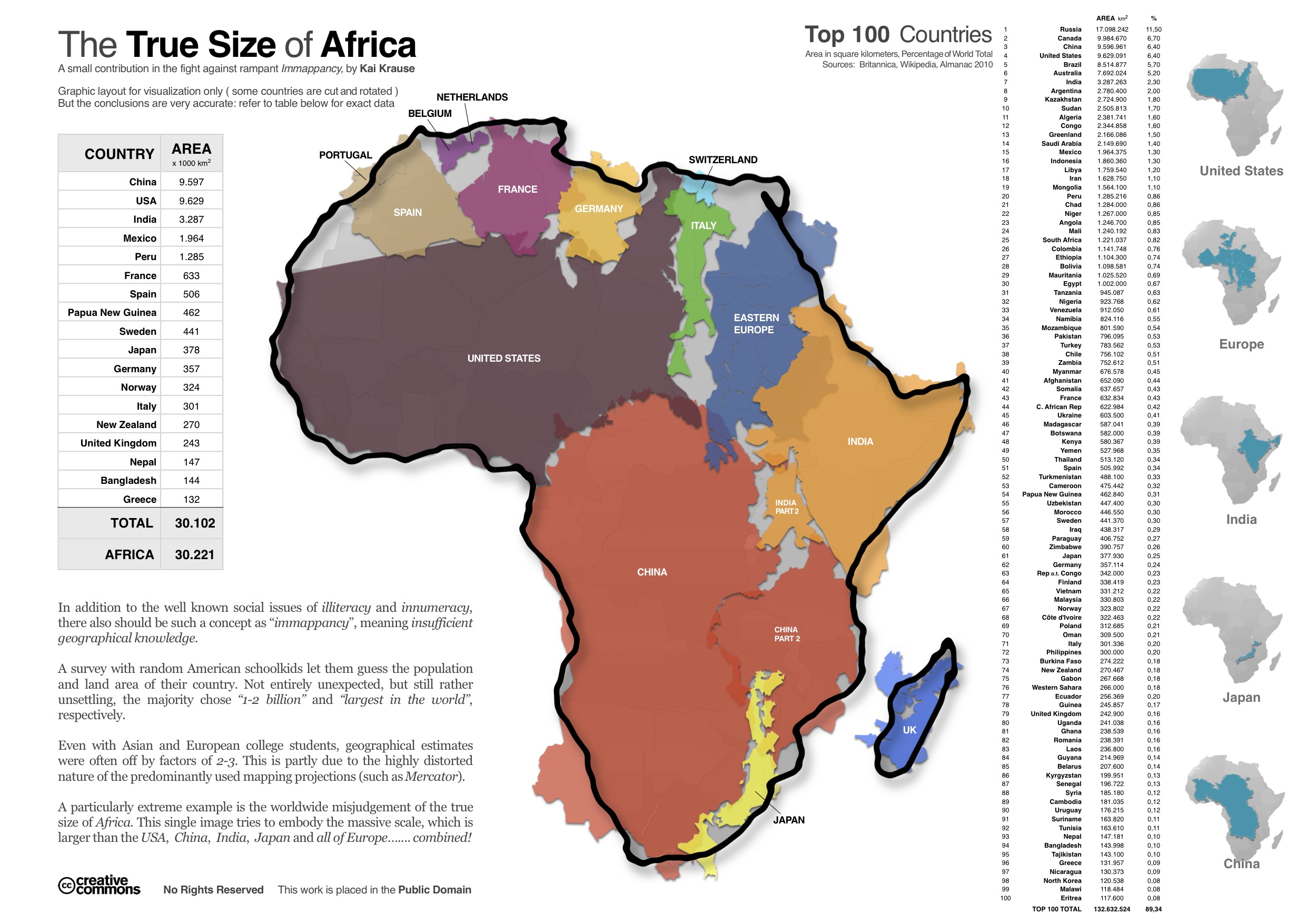
How Big is Africa?

you see OPs like this and you think to yourself "wow, pretty cool pic".

then you read the replies.
 
You figure the Chinese will leave them like the Europeans did? Based on what?

No. I don't think the Chinese will be nearly as stupid as we were. But if they do for some reason, the results will be the same.

“Level of civilization”

You can call the ****holes Europeans created like Rhodesia and the Congo “Free State” a lot of things, but “civilized” ain’t one of them.

Rhodesia was one of the most prosperous states on the African continent, and it managed to remain so despite having both the liberal and communist blocs against it.
 
you see OPs like this and you think to yourself "wow, pretty cool pic".

then you read the replies.

EXACTLY and thats what NORMAL people think . . same when i see the one about Alaska and the rest of the us . . ."hey thats neat"
Just something most people dont think about often
 
EXACTLY and thats what NORMAL people think . . same when i see the one about Alaska and the rest of the us . . ."hey thats neat"
Just something most people dont think about often

yup..
 
size_of_africa.jpg


:popcorn2:
 
No. I don't think the Chinese will be nearly as stupid as we were. But if they do for some reason, the results will be the same.


Rhodesia was one of the most prosperous states on the African continent, and it managed to remain so despite having both the liberal and communist blocs against it.

Rhodesia was a hellhole which resorted to using chemical weapons on the people it was oppressing and still lost.

Rhodesia and weapons of mass destruction - Wikipedia
 
That's probably why Obama had Qaddafi killed. He was about to unite many of the African countries.

Gaddafi was a brutal thug who sponsored terrorism across the globe for decades and who got himself killed. As for him being “about to unite many of the African countries”....considering he fought—-and lost—-a war of aggression against Chad and tried to prop up Idi Amin I highly doubt that.
 
Gaddafi was a brutal thug who sponsored terrorism across the globe for decades and who got himself killed. As for him being “about to unite many of the African countries”....considering he fought—-and lost—-a war of aggression against Chad and tried to prop up Idi Amin I highly doubt that.

Wow...

Got you all steamed up huh?

So, you are OK with Obama setting the stage for Qaddafi's death, so many years after this happened? Right after the Bush administration started having great talks with them?

Really?

Are you proud that one president damages the integrity of the nation from what the previous president sets in place?

Really?

Do you want the trust of the United States with other nations to be questioned when it changes administrations?

Really?

How about starting to look at the facts, instead of rationalizing the planned death of Qaddafi.
 
Hipcrime: You committed one when you opened this book. Keep it up. It's our only hope.

Africa is a sleeping giant and barring humanity destroying itself, WILL be the driving force behind global economic growth.

The only question is who will benefit from that growth, at the moment, the African people?

Or an elite few Africans and foreign owned corporations simply extracting the wealth, it will be a mixed bag, but China appears to want to do the former and they appear to have quite a head start.

Stand on Zanzibar.
 
He acts as if it's a new concept.

However, he compares a continent to countries, apparently not realizing that Africa contains 54 countries.


Actually, he quite obviously recognized that Africa is a continent; specifically, he said, one that you could "stick almost all the popular countries from the other continents into it":

Big enough to stick almost all the popular countries from the other continents into it.


I'm not sure which is better, Mr. Planar:

Case 1. You could not understand that he was simply referring to the size of the African continent or perhaps could not understand the way analogies work, so you thought this was a comparison between the continent of Africa and "countries".

Case 2. You were going for a dishonest *gotcha*, and concluded that claiming he compared a continent to countries was a clever way of making other people think he was foolish.

Both are bad.


How could you misunderstand what he was saying or think anyone else might? "X is big, you can put almost all Y into it" =/= "X is comparable to Y"

Y is being used as a unit of measurement.
 
South Florida ends up in Congo and owned by China? No deal.
 
Big enough to stick almost all the popular countries from the other continents into it.

EOpapMBWkAAmrdY


I've read about the fake maps we grew up with, maps which intentionally minimized the "Dark Continent." But, the pic above really makes that clear, IMO.

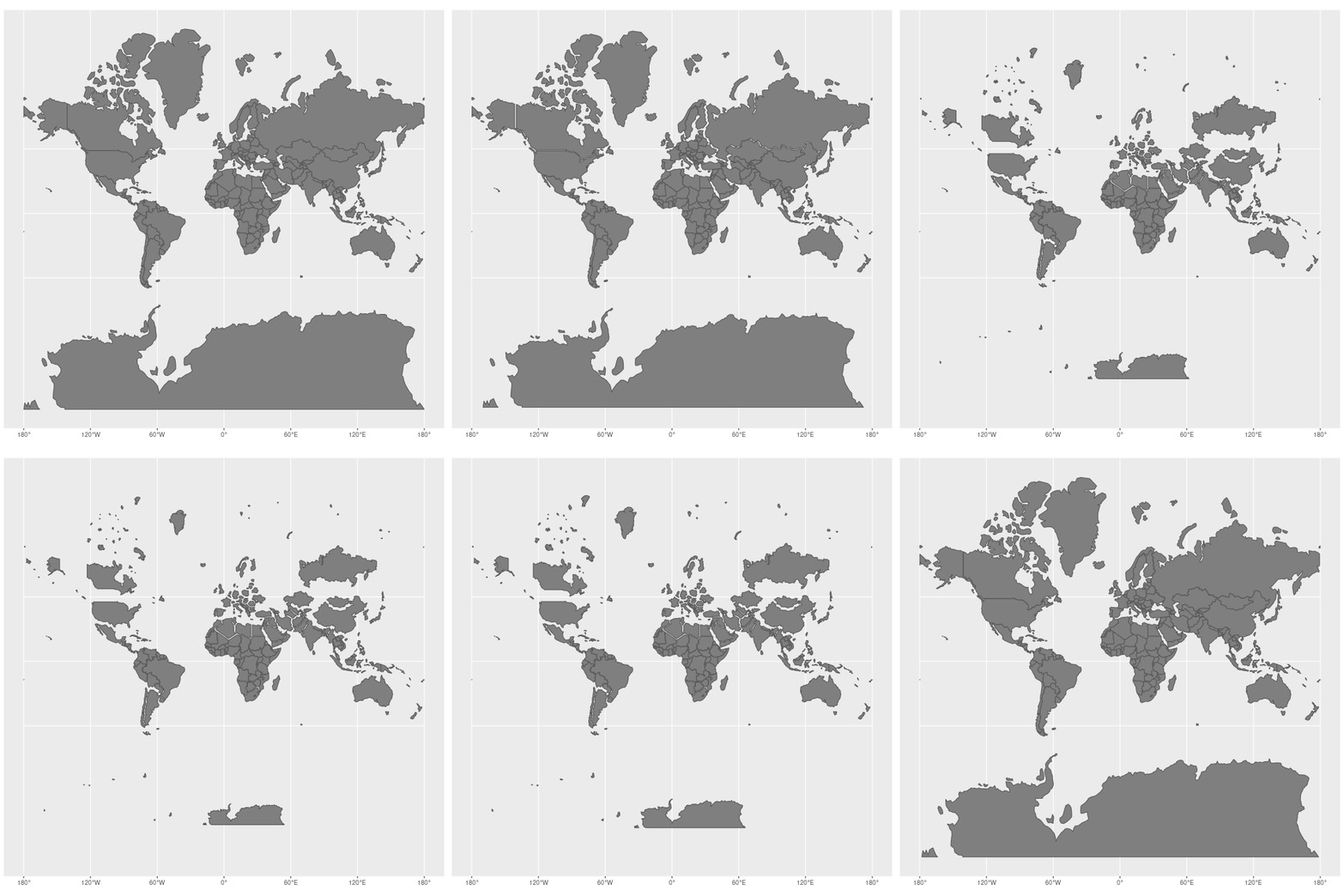
Depicting a spherical object on a flat plane can result in distortions as you approach the poles. The processing is called projection Try doing your experiment on a globe.
 
Wow...

Got you all steamed up huh?

So, you are OK with Obama setting the stage for Qaddafi's death, so many years after this happened? Right after the Bush administration started having great talks with them?

Really?

Are you proud that one president damages the integrity of the nation from what the previous president sets in place?

Really?

Do you want the trust of the United States with other nations to be questioned when it changes administrations?

Really?

How about starting to look at the facts, instead of rationalizing the planned death of Qaddafi.

“Great talks”

Nothing in Gaddafi’s history would suggest that he was even slightly trustworthy. Not a single goddamn thing. The man was a narcissistic thug responsible for the deaths of thousands of people both directly and indirectly. He routinely raped the members of his female bodyguard unit, so he wasn’t simply a mass murderer but a rapist as well. There was zero reason to sit by and let him slaughter who knows how many people until he was convinced all who opposed him were dead.

“Integrity”

Did we promise Gaddafi that he could slaughter as many of his own people as he saw fit?

Did we promise to protect him?

Did we sign a formal treaty allying ourselves with him?

No?

Then there was no question of “integrity” involved.

The facts are that Gaddafi was both directly and indirectly responsible for murdering Americans and deserved all of what he got and more besides.
 
Big enough to stick almost all the popular countries from the other continents into it.

EOpapMBWkAAmrdY


I've read about the fake maps we grew up with, maps which intentionally minimized the "Dark Continent." But, the pic above really makes that clear, IMO.

They aren't "fake maps", it's just the limitations of a Mercator projection map -- trying to fit a sphere onto a flat piece of paper. The opposite effect happens to both the Arctic and Antarctic. There is not conspiracy to minimize or maximize anything.

Mercator projection - Wikipedia
It became the standard map projection for navigation because of its unique property of representing any course of constant bearing as a straight segment. Such a course, known as a rhumb or, mathematically, a loxodrome, is preferred by navigators because the ship can sail in a constant compass direction to reach its destination, eliminating difficult and error-prone course corrections. Linear scale is constant on the Mercator in every direction around any point, thus preserving the angles and the shapes of small objects and fulfilling the conditions of a conformal map projection. As a side effect, the Mercator projection inflates the size of objects away from the equator. This inflation starts infinitesimally, but accelerates with latitude to become infinite at the poles. So, for example, landmasses such as Greenland and Antarctica appear far larger than they actually are relative to landmasses near the equator, such as Central Africa.


Dayum, Alaska just got a pretty big demotion in the adjusted scale.
 
Fun fact: every planet in the solar system can fit between the earth and the moon.

CLqdeKf.jpg
 
Fun fact: every planet in the solar system can fit between the earth and the moon.

View attachment 67272092

The Voyage is a 1 to 10-Billion scale model of the Solar System. It takes about 2000 feet to go from the Sun to Pluto. The Sun, at this scale, is about the size of a grapefruit and the Earth, about 50 feet away, is smaller than the head of a pin.

The Experience | Voyage
 
Ah but only if you tilt Saturn's rings. ;)

Well if you're going to start including bodies in orbit, then the distance of the earth to the moon would have to be factored into the distance between the earth and the moon, which is...problematic.
 
They aren't "fake maps", it's just the limitations of a Mercator projection map -- trying to fit a sphere onto a flat piece of paper. The opposite effect happens to both the Arctic and Antarctic. There is not conspiracy to minimize or maximize anything.

Mercator projection - Wikipedia
It became the standard map projection for navigation because of its unique property of representing any course of constant bearing as a straight segment. Such a course, known as a rhumb or, mathematically, a loxodrome, is preferred by navigators because the ship can sail in a constant compass direction to reach its destination, eliminating difficult and error-prone course corrections. Linear scale is constant on the Mercator in every direction around any point, thus preserving the angles and the shapes of small objects and fulfilling the conditions of a conformal map projection. As a side effect, the Mercator projection inflates the size of objects away from the equator. This inflation starts infinitesimally, but accelerates with latitude to become infinite at the poles. So, for example, landmasses such as Greenland and Antarctica appear far larger than they actually are relative to landmasses near the equator, such as Central Africa.


Worlds_animate.gif
 
Back
Top Bottom