• This is a political forum that is non-biased/non-partisan and treats every person's position on topics equally. This debate forum is not aligned to any political party. In today's politics, many ideas are split between and even within all the political parties. Often we find ourselves agreeing on one platform but some topics break our mold. We are here to discuss them in a civil political debate. If this is your first visit to our political forums, be sure to check out the RULES. Registering for debate politics is necessary before posting. Register today to participate - it's free!

Pennsylvania strikes a blow against gerrymandering distticts

Democrats win the total House of Delegates vote in Virginia by 10 points and still come up short.
It's not just the 43 federal remaps either; it's also the 99 state chamber remaps; with the state chambers doing all 142.

I consider REDMAP 2010 by GOP architect Chris Jankowski to be the most brilliant electioneering I've seen, and I first voted in 1972.
He gave a lengthy interview to Rachel Maddow a few years ago on his model, and frankly, DEMs have copied it.

So, all hands on deck with the Holder/Obama redistricting project to oppose REDMAP 2020 ...

There's so much data collected and available that everything seems to have gotten so sophisticated. While gerrymandering has existed for a long time you can get so granular now-a-days that it's a different ball game. Republicans are typically fine with it right now because the last census happened to fall on a first mid term election year in which they won a large number of states...but the next is the Trump 2nd term election.

A lot of these states have majority Democrats so throw in 2020 census redistricting gerrymandered to the extent that Republicans gerrymandered in 2010 and you end up with near permanent Dem majorities in the state and national houses. I'm sure Republicans will be on the anti-gerrymandering wagon and like most things act like it's some new idea.
 
[h=1]Pennsylvania Supreme Court Strikes Down State's Congressional Map, Saying It Illegally Benefits GOP[/h]


Seems to me that there are a lot of congressional maps that benefit either Republicans or Democrats "clearly, plainly, and palpably," and need to be re drawn by a non partisan entity so as to make elections more fair and congressional seats less secure.

Awesome, good for my state!

hopefully this is the beginning of the end for this nonsense. The software is already out there, hopefully its implemented and controlled by a outside third party with a check system.
 
As long as you aren't starting out with "How do I give my party the biggest advantage as possible" it's fair in my book.

Not a lot to work with there.
 
Then what is the goal of "fair" districting?

To ensure that the representation of those voting reflects similarly to the total vote.
 
To ensure that the representation of those voting reflects similarly to the total vote.

Defined by what? How do you go about doing it?
 
Not a lot to work with there.

Well typically a district drawn that looks like the 2nd North Carolina map rather than the first. The biggest indicator of gerrymandering are those lines which create districts that are not clean. If you create blocks that are relatively straight lined that is pretty fair.

I think another aspect of fairness would be transparency in how the districts were created. Typically all we see are the finished maps that look a Jackson Pollock painting. Lets see the criteria used to create the maps and lets see maps that look like the one I provided earlier.
 
[h=1]Pennsylvania Supreme Court Strikes Down State's Congressional Map, Saying It Illegally Benefits GOP[/h]


Seems to me that there are a lot of congressional maps that benefit either Republicans or Democrats "clearly, plainly, and palpably," and need to be re drawn by a non partisan entity so as to make elections more fair and congressional seats less secure.

Wont that dilute the black vote, the Hispanic vote, the Asian vote, and the LGBTQ-LSMFT communities?
 
The algorithm was written by a software engineer in his spare time. The program takes basic census blocks and creates equal voting districts using it. Below are a couple of picture using North Carolina to show how different they look. The top is the gerrymandered districts where squiggly district lines spread throughout the state in order to group people. The bottom is and example of compactness.

View attachment 67227520View attachment 67227521

Didnt see if you linked any articles or videos to the maps you posted so heres ONE, there more out there and theres other different software too.

https://www.washingtonpost.com/news...ithout-gerrymandering/?utm_term=.462bc88f214d

pa].jpg
 
Last edited:
The algorithm was written by a software engineer in his spare time. The program takes basic census blocks and creates equal voting districts using it. Below are a couple of picture using North Carolina to show how different they look. The top is the gerrymandered districts where squiggly district lines spread throughout the state in order to group people. The bottom is and example of compactness.

View attachment 67227520View attachment 67227521

Sounds like a great idea.

But ...

In that southernmost dark blue "gerrymandered" top map, there's a tentacle that extends to the west along the boundary of the light blue and green district. Let's pretend that the light blue and green district are predominantly rural areas, and the tentacle attached to the west side of the dark blue section is the freeway that attaches an urban city to that southernmost dark blue district. Is it really any better to lump that urban district together with a giant chunk of rural area instead of making an accommodation (the "tentacle") to include their area with another metropolitan district?

While I agree that it is better to have the districts drawn up without bias, I don't know that drawing them up randomly is the answer.
 
Well typically a district drawn that looks like the 2nd North Carolina map rather than the first. The biggest indicator of gerrymandering are those lines which create districts that are not clean. If you create blocks that are relatively straight lined that is pretty fair.

I think another aspect of fairness would be transparency in how the districts were created. Typically all we see are the finished maps that look a Jackson Pollock painting. Lets see the criteria used to create the maps and lets see maps that look like the one I provided earlier.

The specific criteria for creating maps is what I'm looking for here.

I think lots of people have lots of different ideas, and I don't think it's as simple or cut-and-dried as anyone wants to think.
 
Can't read it behind the paywall. What are the answers to the questions?

Its a video. Instead of using your usual schtick of refuting by playing dumb and asking everyone else questions to make them do all the running around for you... you could simply use incognito in your browser to watch it or just state your position which is... simply to refute clearly.
 
Its a video. Instead of using your usual schtick of refuting by playing dumb and asking everyone else questions to make them do all the running around for you... you could simply use incognito in your browser to watch it or just state your position which is... simply to refute clearly.

If you don't want to participate, then don't. There's a perfectly lively and engaging conversation going on without you. Have a good one.
 
Sounds like a great idea.

But ...

In that southernmost dark blue "gerrymandered" top map, there's a tentacle that extends to the west along the boundary of the light blue and green district. Let's pretend that the light blue and green district are predominantly rural areas, and the tentacle attached to the west side of the dark blue section is the freeway that attaches an urban city to that southernmost dark blue district. Is it really any better to lump that urban district together with a giant chunk of rural area instead of making an accommodation (the "tentacle") to include their area with another metropolitan district?

While I agree that it is better to have the districts drawn up without bias, I don't know that drawing them up randomly is the answer.

That's pretty much the crux of the issue. While you want to keep communities together in order ensure that for example rural community with common needs/wants gets the representation they deserve, "keeping communities together" is very malleable. It can be used to create these non-compact districts to clump all voters of one party into the least number of districts.
 
The specific criteria for creating maps is what I'm looking for here.

I think lots of people have lots of different ideas, and I don't think it's as simple or cut-and-dried as anyone wants to think.

It's definitely not cut and dried but it's very obvious when extreme gerrymandering takes place.
 
It's definitely not cut and dried but it's very obvious when extreme gerrymandering takes place.

Yeah, gerrymandering can be obvious. But coming up with a system that everyone agrees is "fair" and proper is a lot more elusive than people want to think.

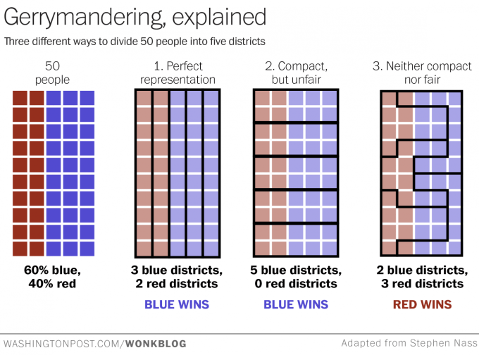
I mean, a lot of people point to this graphic:

imrs-php-1.png


But you can see the problems. People don't line themselves up in neat rows geographically. And also, as I mentioned before, sectioning people off by party is its own kind of gerrymandering.

Seems to me that districting should be based mostly on reasonable geography. But there are plenty of ways that it can cause problems and produce results that someone's going to call "unfair," such as in the third column (no. 2) of the graphic. It's called unfair because the geography doesn't produce the partisan result that whoever created it thinks it should, but it's not obviously unfair.
 
Yeah, gerrymandering can be obvious. But coming up with a system that everyone agrees is "fair" and proper is a lot more elusive than people want to think.

I mean, a lot of people point to this graphic:

imrs-php-1.png


But you can see the problems. People don't line themselves up in neat rows geographically. And also, as I mentioned before, sectioning people off by party is its own kind of gerrymandering.

Seems to me that districting should be based mostly on reasonable geography. But there are plenty of ways that it can cause problems and produce results that someone's going to call "unfair."

That's the key, districting shouldn't take party into account or voting patterns. Currently that is exactly the key measure used to draw districts. That's why I believe it's more about transparency in how the districts were created and more uniform/compact blocked districts. As you mention, variation and voting patterns based on density and geography won't create a situation where one party gets 51% of the votes therefore they get 51% of the seats...but...those differences based on randomly drawn districts is something people can live with much more than districts drawn that create massive unequal results.
 
That's the key, districting shouldn't take party into account or voting patterns. Currently that is exactly the key measure used to draw districts. That's why I believe it's more about transparency in how the districts were created and more uniform/compact blocked districts. As you mention, variation and voting patterns based on density and geography won't create a situation where one party gets 51% of the votes therefore they get 51% of the seats...but...those differences based on randomly drawn districts is something people can live with much more than districts drawn that create massive unequal results.

Well, I think if you are trying to district in order to produce a specific result, be it for advantage, OR because you think it's the "fair" outcome, it's two sides of the same coin.

I'd say do it geographically and by population, and the electoral chips fall where they may. We seem to be more or less in agreement in principle, though details are harder.

Geographically and population would be the way to go

Make the districts as square as possible, and as much as possible along county lines. Rural being kept rural and urban being kept urban as much as possible to ensure roughly equal populations in each district. A total lack of consideration regarding voting patterns would be a must

So yes a rural district might elect a republican with 80% of the vote, and an urban district might vote a democrat with 85% of the vote. But to redraw the district to include 15% more democrats into the rep district with 80% of the vote to make a democratic district less like have a democratic winner (and vice versa) should be prevented when drawing the districts

I would think it would be a major requirement, yes.
 
I can see that point of view, but what is the larger problem...a party building in an advantage or the need to group similar people into a district? The Wisconsin example used in the recent Supreme Court case is pretty remarkable. Slim majorities in votes turns into super majority and actually losing the elections resulting in a majority. That's pretty disenfranchising as well, not to mention it's very undemocratic.

What is the "larger problem" is dependent upon what and who a Congressional representative is supposed to represent, not which national party benefits (which is a problem, but it is "the smaller problem").

For example, long and skinny boundaries drawn around the port communities of the Mississippi might better represent a collective community of interest than a the "compact" quartering of a State into random mixes of urban and farming interests. To the maximum degree practical, it would seem that keeping communities whole should be the first goal (e.g. east Contra Costa and Alameda Counties of California have far more in common with one another than the urbanized centers of the west sides of those counties...but they are each split between the two congressional districts).
 
Back
Top Bottom