• This is a political forum that is non-biased/non-partisan and treats every person's position on topics equally. This debate forum is not aligned to any political party. In today's politics, many ideas are split between and even within all the political parties. Often we find ourselves agreeing on one platform but some topics break our mold. We are here to discuss them in a civil political debate. If this is your first visit to our political forums, be sure to check out the RULES. Registering for debate politics is necessary before posting. Register today to participate - it's free!

Bend Over And Kiss Your Ass Goodbye, The Planet is Baking

The idea that station data, which covers only 23% of the earth's surface, could be more accurate than satellite data, which covers everything between 80 and -80 degrees latitude, is really pretty silly. The only reason that warmists cling to this obsolete and outmoded method of measuring the earth's temperatures is that 1) they have control of the data and can make it look any way they like and 2) it runs a lot warmer than the satellite data, which is, of course, probably by design.

The other stupid trope they float out when trying to defend their station data is the fact that satellite data measures the temperature of the entire volume of air, not just the temperature at the surface. As if this is a defect, and what is measured does not relate to global temperatures!

Satellites don't even 'measure temperature' at all. Both surface and satellite data are useful. You just seem to want to exclude the data you don't like and repeat the "stupid trope" that science deniers float out "the satellite data is the best data we have". It's not.

That's why I posted the video with Dr Carl Mears from RSS and other scientists. I suggest you watch it. The surface data is far more accurate and reliable - according to the scientists creating the satellite datasets themselves.

You sound like a crazy climate truther when you claim "which is, of course, probably by design."
 
Last edited:
Have you got any legitimate sources (eg published papers) rather than the fake "Steve Goddard"'s climate truther conspiracy blog?
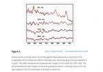
Radiosonde Atmospheric Temperature Products for Assessing Climate (RATPAC): A new data set of large-area anomaly time series - Free - 2005 - Journal of Geophysical Research: Atmospheres - Wiley Online Library
Radiosonde.jpg
You can see the lower troposphere (850 mb) shows only minor warming since the 1950's
The reason the models model the surface troposphere system, is because the actual surface is way too noisy.
Temperatures vary by several degrees over a lateral distance of just a few feet.
 
Radiosonde balloons don't measure surface temperature, so what are you talking about? The satellite datasets have diverged in recent years from the radiosonde balloon datasets. RSS have just corrected some of the errors and published a new version (v4) of their TMT and TTT datasets and have cautioned against using their v3.3 TLT dataset because of the same problems. UAH are still stuffing around trying to correct their datasets with their beta 6 versions.

Where did you get the crazy idea that "the models do not model surface temperature"?

Try not to limit yourself to automatically believing any junkscience nonsense you read on Steve Goddard's climate truther conspiracy blog or you'll just look crazy.

Here's some background reading on balloon radiosonde data:

Radiosonde Atmospheric Temperature Products for Assessing Climate (RATPAC)

Integrated Global Radiosonde Archive (IGRA)

If I get time, maybe I'll do a literature search for some papers.
I am getting the idea that the models do not model the surface temperature from the IPCC
key concepts in climate science section.
http://www.grida.no/climate/ipcc_tar/wg1/pdf/tar-01.pdf
If the amount of carbon dioxide were doubled instantaneously,
with everything else remaining the same, the outgoing infrared
radiation would be reduced by about 4 Wm−2. In other words, the
radiative forcing corresponding to a doubling of the CO2
concentration would be 4 Wm−2.
To counteract this imbalance,the temperature of the
surface-troposphere system would have to increase
by 1.2°C (with an accuracy of ±10%),
in the absence of other changes.
Note, they do not call out the surface temperature, but the surface-troposphere system.
 
The paper is 11 years old, the data only goes to 1999, and the paper doesn't support the claims you made in your previous post that the satellite data are in agreement with the radiosonde data.

You also need to read what the authors wrote, not just rely on eyeballing a graph. "The global mean time series from the (CARDS-based) unadjusted LKS and IGRA for the 85 stations used in this work differ most notably before 1965 (Figure 1). Although IGRA is an improvement over CARDS, we do not have LKS adjustments based on IGRA. Because of the careful scrutiny used by the LKS team to create the adjusted LKS data, LKS is likely to be more reliable than a data set derived by applying the FD method to the IGRA data before 1995. (In 1996 and 1997, the LKS adjustments are less reliable than for earlier periods because of the small number of data points present after the adjustments. For these years, the FD result is likely to be equally valid.) We therefore use LKS instead of IGRA before 1995 to reap the substantial benefits of the LKS homogeneity adjustments. However, because of the differences between the data sets before 1965, RATPAC data from that period should be viewed with caution."

850mb is at about 5000 ft so why would you expect it to show the same warming as at the surface about 6 ft off the ground?

The reason the models model the surface troposphere system, is because the actual surface is way too noisy.
Temperatures vary by several degrees over a lateral distance of just a few feet.
You're claim that models don't model the surface data is just flat wrong. You also don't seem to have a clue about why anomalies are used instead of absolute temperatures. Jesus. Yet another climate truther who never bothers to do something even as simple as reading the FAQ from the GISS website. I have no doubt it's been pointed out to you a number of times, including by Mithrae just a few days ago. Do you just totally ignore anything that might contradict what you want to hear? :shock:

Data.GISS: GISTEMP -- Frequently Asked Questions

I noticed you totally ignored the 2015 Po-Chedley paper I posted.
 
I am getting the idea that the models do not model the surface temperature from the IPCC
key concepts in climate science section.
http://www.grida.no/climate/ipcc_tar/wg1/pdf/tar-01.pdf

Note, they do not call out the surface temperature, but the surface-troposphere system.

So you think that means models don't model the surface temperature? Really?

Have you done any sort of reading about how climate models work and what they do at all?

How about watching lectures:

TED Talks 2014- The Emergent Patterns of Climate Change - Gavin Schmidt

TEDx University of Toronto 2014: Computing the Climate- Steve Easterbrook

I'm wasting my time with you aren't I? If you still haven't even read something as simple as the GISS FAQ about anomalies after how many years posting on this forum, you're not likely to want to watch some lectures on climate modeling.
 
Last edited:
Satellites don't even 'measure temperature' at all. Both surface and satellite data are useful. You just seem to want to exclude the data you don't like and repeat the "stupid trope" that science deniers float out "the satellite data is the best data we have". It's not.

That's why I posted the video with Dr Carl Mears from RSS and other scientists. I suggest you watch it. The surface data is far more accurate and reliable - according to the scientists creating the satellite datasets themselves.

You sound like a crazy climate truther when you claim "which is, of course, probably by design."

Scientists went to the trouble of measuring global temperature in a manner that is comprehensive, and all done by a single instrument, the satellite, for the ultimate in uniformity. And then the warmists reject it because it doesn't agree with their preconceived notions. Their rational for rejecting it is completely bogus.

You're not measuring temperature with a thermometer, either. You're measuring the expansion of mercury or alcohol, or maybe the resistance of a wire or the voltage across a thermocouple. All of these measurements correlate with temperature, just as microwave radiation detected by an MSU does.

Tell me this: How do you get an accurate measurement of 100% of the earth's surface when there are thermometers on only about 23% of it? You don't, of course. You guesstimate.
 
The paper is 11 years old, the data only goes to 1999, and the paper doesn't support the claims you made in your previous post that the satellite data are in agreement with the radiosonde data.

You also need to read what the authors wrote, not just rely on eyeballing a graph. "The global mean time series from the (CARDS-based) unadjusted LKS and IGRA for the 85 stations used in this work differ most notably before 1965 (Figure 1). Although IGRA is an improvement over CARDS, we do not have LKS adjustments based on IGRA. Because of the careful scrutiny used by the LKS team to create the adjusted LKS data, LKS is likely to be more reliable than a data set derived by applying the FD method to the IGRA data before 1995. (In 1996 and 1997, the LKS adjustments are less reliable than for earlier periods because of the small number of data points present after the adjustments. For these years, the FD result is likely to be equally valid.) We therefore use LKS instead of IGRA before 1995 to reap the substantial benefits of the LKS homogeneity adjustments. However, because of the differences between the data sets before 1965, RATPAC data from that period should be viewed with caution."

850mb is at about 5000 ft so why would you expect it to show the same warming as at the surface about 6 ft off the ground?


You're claim that models don't model the surface data is just flat wrong. You also don't seem to have a clue about why anomalies are used instead of absolute temperatures. Jesus. Yet another climate truther who never bothers to do something even as simple as reading the FAQ from the GISS website. I have no doubt it's been pointed out to you a number of times, including by Mithrae just a few days ago. Do you just totally ignore anything that might contradict what you want to hear? :shock:

Data.GISS: GISTEMP -- Frequently Asked Questions

I noticed you totally ignored the 2015 Po-Chedley paper I posted.
From earlier discussions the modeled layers are 1 degree latitude/longitude, with a vertical resolution of 30 or 40 hPa, or 800 to 1000 feet.
So the modeled surface-troposphere system layer would at best be about 70 miles square, and 800 feet thick.
Now let's compare that to one maybe two stations in that 70 X 70 mile square, with sensors 5 feet off the ground.
Do you think those two stations would accurately represent such a volume of air?
The reason they cannot model the surface temperature is something called the interfacial layer.
If you look at the radiosonde data, there is always a hook near the surface, where the height to temperature
reverses.
 
Scientists went to the trouble of measuring global temperature in a manner that is comprehensive, and all done by a single instrument, the satellite, for the ultimate in uniformity. And then the warmists reject it because it doesn't agree with their preconceived notions. Their rational for rejecting it is completely bogus.

You're not measuring temperature with a thermometer, either. You're measuring the expansion of mercury or alcohol, or maybe the resistance of a wire or the voltage across a thermocouple. All of these measurements correlate with temperature, just as microwave radiation detected by an MSU does.

Tell me this: How do you get an accurate measurement of 100% of the earth's surface when there are thermometers on only about 23% of it? You don't, of course. You guesstimate.

It's like being able to predict the outcomes of elections with polls of a few thousand voters, or being able to see the effect of a drug in millions of patients with only a ten thousand patient trial!

Everyone knows that's impossible!
 
So you think that means models don't model the surface temperature? Really?

Have you done any sort of reading about how climate models work and what they do at all?

How about watching lectures:

TED Talks 2014- The Emergent Patterns of Climate Change - Gavin Schmidt

TEDx University of Toronto 2014: Computing the Climate- Steve Easterbrook

I'm wasting my time with you aren't I? If you still haven't even read something as simple as the GISS FAQ about anomalies after how many years posting on this forum, you're not likely to want to watch some lectures on climate modeling.
I am not sure why you think the GISS FAQ, which deals with observed surface temperatures would discuss
model shortcoming of theoretical data.
 
The idea that station data, which covers only 23% of the earth's surface

You don't know what you're talking about, do you?

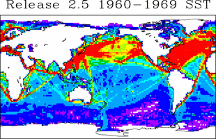
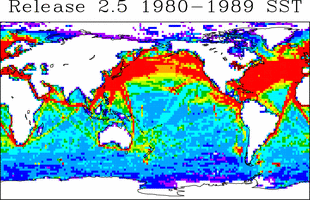
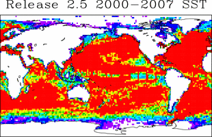
There are numerous sea surface temperature data sets available to observers: GISS for example uses the Extended Reconstructed Sea Surface Temperature (ERSST v4), which prior to 2008 uses NOAA's International Comprehensive Ocean-Atmosphere Data Set (ICOADS R2.5).

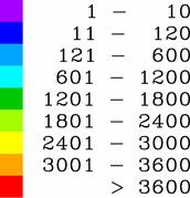
This data set includes from about 1 million reports per year in the mid 1950s up to 16 million in 2007. The regional oceanic coverage is shown below:
r2.5sst_fig17c.gif
. . .
r2.5_fig3.gif


r2.5sst_fig19c.gif
. . .
r2.5sst_fig21c.gif

You don't know what you're talking about, do you. There are actual measurements for only 23% of the earth's surface. Everything else is determined by extrapolation and estimation.

The GISS data set is an outmoded fossil and should be scrapped. They don't even know the condition of most of the stations or whether they are sited appropriately.
 
You don't know what you're talking about, do you. There are actual measurements for only 23% of the earth's surface.

Well I suppose you've got one person who is just going to take your word for that over NOAA's :roll:

Power of wishful thinking I guess.
 
You don't know what you're talking about, do you. There are actual measurements for only 23% of the earth's surface. Everything else is determined by extrapolation and estimation.

The GISS data set is an outmoded fossil and should be scrapped. They don't even know the condition of most of the stations or whether they are sited appropriately.

23%? Where do you get that number?

They can only really measure the temperature in the immediate proximity of the thermometer.
Given that the tips of thermometers are only a fraction of an inch long, and even a million of them would not take up more than an acre, clearly the percentage of the earth covered is a mere fraction of the surface area- like .000000001%.

ITS CLEARLY A LIBRUL CONSPIRACY!


Sent from my iPad using Tapatalk
 
For the record, in one of our past discussions as you may recall I looked at the AR5 best estimates of black carbon on snow forcing (equivalent to 0.12W/m^2 of CO2 global average)

This 0.12 W/m^2 global is only affecting maybe 10% of the earth, as it has very little effect outside of ice. If it is only affecting 10% of the earth, then in that region, it is 1.2 W/m^2. That is quite a bit to add to ice melting.

Still, I say that is a dramatic underestimate. In the summertime when the ice melts, the total solar energy is pretty good. If we change the albedo of the northern ice from an albedo of 85, to 70... We have doubled the solar absorption from 15% to 30%.

Now tell me that is insignificant.
 
When you fail to provide evidence of such dramatic claims, any reasonable person should be sceptical.

Every time I provide evidence, you guys come back with a blog like Skeptical Science.

Why should I bother searching for a paper I provided before, that you science deniers ignore?
 
Back
Top Bottom