• This is a political forum that is non-biased/non-partisan and treats every person's position on topics equally. This debate forum is not aligned to any political party. In today's politics, many ideas are split between and even within all the political parties. Often we find ourselves agreeing on one platform but some topics break our mold. We are here to discuss them in a civil political debate. If this is your first visit to our political forums, be sure to check out the RULES. Registering for debate politics is necessary before posting. Register today to participate - it's free!

New Research Finds Antarctica’s Ice Shelves Are Melting Rapidly

While saying I would not insure a beach front for 30 years, because of many reasons, sea level not being among them.
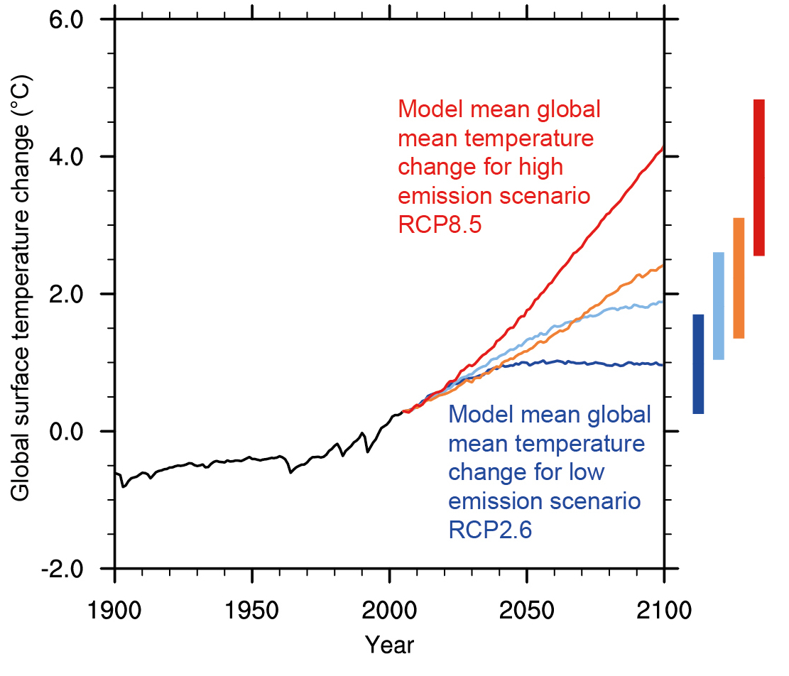
The sea level in Miami is only increasing by about .21 inches per year,
according to the NOAA certified gauge at Virginia Key.
Water, Water, Everywhere: Sea Level Rise in Miami | RSMAS Blog

If anything the Rate of the Rise appears to be Slowing down.
While the sea level may only increase by 9.25" by 2060, any good king tide could throw an extra 60 inches in during
the spring flood season.
Now that's just an Outright lie.
YOUR link says the Opposite several times!

"..The mean sea level has risen Noticeably in the Miami and Miami Beach areas just in the past Decade. Flooding events are getting more frequent, and some areas flood during particularly high tides now: no rain or storm surge necessary. Perhaps most Alarming is that the Rate of sea level Rise is Accelerating.
[......]
As eluded to in the introduction, Sea level is Not just rising here, the Rate of the Rise is Accelerating. If the seasonal cycle (black line in the figure above) is subtracted from the data, as well as the mean of all of the data, a series of trendlines can be generated (see figure below). Removing the dominant annual and semi-annual cycles from the time series leaves only daily variability, miscellaneous cycles, and trends. The data are color-coded by arbitrary 5-year periods (red is 2011-2015, green is 2006-2010, blue is 2001-2005, and purple is 1996-2000). The trendlines are drawn through the past 5 years (red), 10 years (green), 15 years (blue), and 20 years (purple). There is plenty of daily and intra-annual variability of course, but what stands out is the increasing slopes of the linear trends in more recent periods. Over the past 20 years, the average high tide has increased by 0.22 inches/year, which agrees very closely with the trend shown in the first chart using annual averages (0.21 inches/year). However, notice that the trends over shorter and shorter periods become Increasingly Rapid."..."​

So sea level should certainly be one of anyone's reasons for not writing a mortgage. Ignoring that is denialist. YOUR link says sea level has risen noticeably in just the last decade.

And what an outrageous mischaracterization of Your own link.

EDIT to immediately below.
My charge stands about your Outrageous MIScharacterization of Your own Link: just taking one OUT of context snippet from an article that says the Opposite!
And THANKS for that Link which backs my claim 100%, and makes a Mockery of everything you ever posted here.
You probably thought no one would read it. Oucher.
 
Last edited:
Now that's just an Outright lie.
YOUR link says the Opposite several times!

"..The mean sea level has risen Noticeably in the Miami and Miami Beach areas just in the past Decade. Flooding events are getting more frequent, and some areas flood during particularly high tides now: no rain or storm surge necessary. Perhaps most Alarming is that the Rate of sea level Rise is accelerating.
[......]
As eluded to in the introduction, Sea level is Not just rising here, the Rate of the Rise is Accelerating. If the seasonal cycle (black line in the figure above) is subtracted from the data, as well as the mean of all of the data, a series of trendlines can be generated (see figure below). Removing the dominant annual and semi-annual cycles from the time series leaves only daily variability, miscellaneous cycles, and trends. The data are color-coded by arbitrary 5-year periods (red is 2011-2015, green is 2006-2010, blue is 2001-2005, and purple is 1996-2000). The trendlines are drawn through the past 5 years (red), 10 years (green), 15 years (blue), and 20 years (purple). There is plenty of daily and intra-annual variability of course, but what stands out is the increasing slopes of the linear trends in more recent periods. Over the past 20 years, the average high tide has increased by 0.22 inches/year, which agrees very closely with the trend shown in the first chart using annual averages (0.21 inches/year). However, notice that the trends over shorter and shorter periods become Increasingly Rapid."..."​

So sea level should certainly be one of anyomne's rationale fro not writing a mortgage. Ignoring that is denialist.

And what an outrageous mischaracterization of Your own link.

From the link,
Over the past 20 years, the average high tide has increased by 0.22 inches/year, which agrees very closely with the trend shown in the first chart using annual averages (0.21 inches/year).
Also the not on the shorter periods.
Be advised that simple linear trends of noisy time series are not reliable for extrapolating very far into the future, nor are the trend values reliable for shorter time periods.
 
How much does Florida beach front property cost?

How much would it cost to build a 3 foot high concrete wall across it?

The beach front property will be vastly more valuable by 2060 due to us all getting richer and wanting to live on the beach.
 
Oh No...
The sky is falling...
This has never happened before...
Access : Rapid sea-level rise and reef back-stepping at the close of the last interglacial highstand : Nature
I guess the now extinct dominate species from 121 kyrs ago, must have created global warming then, too...
Actually they didn't, but as we do..

Long-term Sea-level Rise | Features | News | College of Earth, Ocean, and Atmospheric Sciences | Oregon State University

.."The simulations of future scenarios we ran from physical models were fairly consistent with evidence of sea-level rise from the past," Clark added. "Some 120,000 years ago, for example, it was 1-2 degrees warmer than it is now and Sea levels were about Five to Nine Meters higher. This is consistent with what our models say may happen in the future.".."​

So if you don't mind sea level 16-30 feet higher. No problem. Of course, NYC, (whole East Coast) London, Shanghai, etc, etc, might have issues.
 
Last edited:
Actually they didn't, but as we do..

Long-term Sea-level Rise | Features | News | College of Earth, Ocean, and Atmospheric Sciences | Oregon State University

.."The simulations of future scenarios we ran from physical models were fairly consistent with evidence of sea-level rise from the past," Clark added. "Some 120,000 years ago, for example, it was 1-2 degrees warmer than it is now and Sea levels were about Five to Nine Meters higher. This is consistent with what our models say may happen in the future.".."​

So if you don't mind sea level 16-30 feet higher. No problem. Of course, NYC, (whole East Coast) London, Shanghai, etc, etc, might have issues.

Well, how can that article have any credibility when the paper isn't linked?

Ever deal with a liberal college journalist in Corvallis Oregon?

I found two recent studies about sea level authored by Peter Clark in PNAS, and neither of them make the claim of the 2.3 meters per degree.

Maybe you can help us, and find the study the unnamed journalist is referring to.
 
LOL...

I have a simple exercise for you.

Calculate the heat required to melt all that ice on Greenland.

Tell us then if you think it is possible for that to happen in under 500 years.

Just for fun....

30 million km[SUP]3[/SUP] x 333.55 kJ/Kg = [taking 1 cubic km as 1Gt of water, close enough] 30 x 10[SUP]6[/SUP] x 10[SUP]9 [to get to tonnes][/SUP] x 10[SUP]3 [to get to kg][/SUP]

= 10,006.5 x 10[SUP]18[/SUP] = 10[SUP]21[/SUP] kJ

Surface area of Greenland's ice sheet; 1.71 million km[SUP]2[/SUP]

So that would need 10[SUP]21[/SUP] / 1.71 x 10[SUP]12 [to get to energy per square meter needed][/SUP] = 5.8 x 10[SUP]9[/SUP] kJ/m[SUP]2[/SUP]

The intensity of solar radiation is about 1050 J/m[SUP]2[/SUP] at maximum.

The ice on Greenland is never exposed to this as it it at a high latitude and will only ever be exposed to very slanted rays.

The albedo of the ice will refect 90%+ (like 98%) of the incoming energy from the sun.

The ice is very cold to begin with and will take considerable extra energy to warm up to melting point in the first place.

The way ice melts, especially in dry conditions of low atmospheric pressure is that it goes from ice to water vapor without being liquid mostly. This will make the energy which would have melted the ice be mostly used to take most of the ice to vapor thus reducing the ice melt by 70% or so.

This will all have to happen at temperatures above freezing. This happens for all of 4 weeks in a hot summer on the central ice sheet of Greenland.

Were Greenland's ice melt to keep up with the snow fall of 1m+ (water equivalent) then during the 4 week summer there would be rivers with the combined flow rate of 45 Mississippis running off it. There are not any such vast rivers. In fact there might just be about half a Mississipppi.
 
Well, how can that article have any credibility when the paper isn't linked?
Ever deal with a liberal college journalist in Corvallis Oregon?
I found two recent studies about sea level authored by Peter Clark in PNAS, and neither of them make the claim of the 2.3 meters per degree.
Maybe you can help us, and find the study the unnamed journalist is referring to.
Of Course I can, But I don't need to. 2.3 M per degree serves the purpose quite well!
A Climate Skeptic Blog No less.

Did an ice sheet collapse 120,000 years ago pushing sea levels up to 9m higher than today?
Did an ice sheet collapse 120,000 years ago pushing sea levels up to 9m higher than today? « JoNova

"Proving that nature can outdo anything humans have done, a new paper shows that sea-levels off Western Australia may have risen as high as 9 m above the current level during the last warm period over a hundred thousand years ago. The authors (O’Leary et al) conclude that seas were 3-4 m higher for most of the last warm period (known as the Eemian) but towards the end of the period a large sudden rise occurred. They suggest that an ice shelf collapsed in Antarctica or Greenland or both, causing a 5m rise (17 feet).".."​

so even before the Collapse we had 3-4 M/10'-13' higher than today.
Wonderful!
And many warn the same could happen again. You reach a tipping point on temperature and an/Some Ice Tray can fall off the table.
But even using 2.3M per degree is 7.5' per degree. Possibly 15' by 2100.


https://www.epa.gov/climate-change-science/future-climate-change
EPA.gov
scenariotempgraph_0.jpg


The Mean temperature rise est is about 2 degrees x 2.3 Meters = 4.6 Meters = 15' by 2100.
 
Last edited:
Of Course I can, But I don't need to. 2.3 M per degree serves the purpose quite well!
A Climate Skeptic Blog No less.

Did an ice sheet collapse 120,000 years ago pushing sea levels up to 9m higher than today?

I understand that you want simple answers to such questions but I'm affraid that the real world is more complex than you want it to be.

If there had been such a sudden loss of an ice sheet 120,000 years is not long enough for it to rebuild without leaving the evidence of it's loss being obvious.

If there were sea levels as high as talked about in Austrailia then why were they not everywhere?

If you look at my previous post in this thread you will begin to see the very very basic start point of how you must think about these things. Having an x amout of sea level rise per degree is totally stupid. You must look at each location where there is significant ice and see what temperature rise there would cause significant melting. Its' not hard.
 

I understand that you want simple answers to such questions but I'm affraid that the real world is More Complex than you want it to be.

If there had been such a sudden loss of an ice sheet 120,000 years is Not long enough for it to rebuild without leaving the Evidence of it's loss being obvious. If there were sea levels as high as talked about in Austrailia then why were they not everywhere?

If you look at my previous post in this thread you will begin to see the very very basic start point of How You Must Think about these things. Having an x amout of sea level rise per degree is totally stupid. You must look at Each location where there is significant ice and see what temperature rise there would cause significant melting. Its' not hard. [/ COLOR]
Disguised as somehow knowledgeable/patronizing, this is no more than BS/an attempt at ambiguation to my very coherent reply to/refutation of LoP. LoP who could NOT answer despite reading my post several times. Others too.
Additionally, it's an attempt at the complication/demand detail fallacy. (see bolded quote parts for those goofy tries/prefixes to them)
 
Astonishing really.
Perhaps you should toss a few Ice Cubes in a full glass of water and tell us what happens: if it shrinks.
Or the more analogous: put the tray of ice cubes on a slant just above the water, and let it melt, or slide in, in partially melted form.

I really can't believe how, how, ...... this post is.


Physics..
 
LoP who could NOT answer despite reading my post several times.

I don't even remember what you wanted. Did I say it was something I covered before, and didn't want to waste the time looking it up again

Words have meaning. Did I say can't, or won't?

What grade are all you warmers in anyway? 5th grade?

Are you so arrogant to think I'm going to answer ever question from someone who responds with blogs and parrots pundits rather than papers?
 

[h=1]2015 Antarctic Maximum Sea Ice Extent Breaks Streak of Record Highs[/h]From NASA Goddard: The sea ice cover of the Southern Ocean reached its yearly maximum extent on Oct. 6. At 7.27 million square miles (18.83 million square kilometers), the new maximum extent falls roughly in the middle of the record of Antarctic maximum extents compiled during the 37 years of satellite measurements – this year’s…

October 16, 2015 in Antarctic, Sea ice.

Apparently conditions changed dramatically in just a year. It's either that, or perhaps someone is cherry picking selective data to create a false impression.
 
Last edited:
Apparently conditions changed dramatically in just a year. It's either that, or perhaps someone is cherry picking selective data to create a false impression.
And uh, WHO is likely to be "Cherry Picking"?
A New article in the [Conservative] WSJ, and Nasa/JPL... or a 2 year Old posting on WUWT: an Infamous climate skeptic Blog?

I see the old politico.com Mafia is out in force again. Full posting and 'like' support.. Never facts.
These guys just go around the board with team play and 50% of each others 'likes'.
 
Last edited:
"Archimedes Principal" only applies when/if the Ice (your Ice cube) is already in the Water.


Duh...

Most of the areas spoken of are. That which is on land is limited.
 
And uh, WHO is likely to be "Cherry Picking"?
A New article in the [Conservative] WSJ, and Nasa/JPL... or a 2 year Old posting on WUWT: an Infamous climate skeptic Blog?

I see the old politico.com Mafia is out in force again. Full posting and 'like' support.. Never facts.
These guys just go around the board with team play and 50% of each others 'likes'.

Maybe you can square the data in the OP with Nasa in the article Jack linked, or at least present what occurred in the interim that would cause such a disparity. Let me disabuse you of the notion that I expect any honesty from you. Otherwise your second comment above would actually mean something.
 
And uh, WHO is likely to be "Cherry Picking"?
A New article in the [Conservative] WSJ, and Nasa/JPL... or a 2 year Old posting on WUWT: an Infamous climate skeptic Blog?

I see the old politico.com Mafia is out in force again. Full posting and 'like' support.. Never facts.
These guys just go around the board with team play and 50% of each others 'likes'.

Yeah. You can't trust those NASA Goddard guys.:roll::lamo:mrgreen:
 
Oh No...

The sky is falling...

This has never happened before...

Access : Rapid sea-level rise and reef back-stepping at the close of the last interglacial highstand : Nature

I guess the now extinct dominate species from 121 kyrs ago, must have created global warming then, too...

"In our warming world, the implications of a rapid, metre-scale sea-level jump late during the last interglacial are clear for both future ice-sheet stability and reef development. Given the dramatic disintegration of ice shelves and discovery of rapid ice loss from both the Antarctic and Greenland ice sheets, the potential for sustained rapid ice loss and catastrophic sea-level rise in the near future is confirmed by our discovery of sea-level instability at the close of the last interglacial. Furthermore, the inhibition of reef development that this instability caused has negative implications for the future viability of modern reefs, which are already being impacted by anthropogenic activity on a global scale."
 
Apparently conditions changed dramatically in just a year. It's either that, or perhaps someone is cherry picking selective data to create a false impression.

Perhaps learn the difference between ice-shelves (OP article) and sea ice (WUWT blog)?

But speaking of Antarctic sea-ice:

“Within the space of just two years, we have gone from a record high winter sea-ice extent to record daily lows for this point in the season.”

Source:
Low winter sea ice coverage around Antarctica

sea_ice_extent_aug-sep_2016.gif

Figure 1: Dark blue line represents 2016 sea ice extent. Light blue area represents maximum/minimum recorded extent between 1979-2015. Black line represents average extent between 1979-2015
 
Perhaps learn the difference between ice-shelves (OP article) and sea ice (WUWT blog)?

But speaking of Antarctic sea-ice:

“Within the space of just two years, we have gone from a record high winter sea-ice extent to record daily lows for this point in the season.”

Source:
Low winter sea ice coverage around Antarctica

View attachment 67210383

Figure 1: Dark blue line represents 2016 sea ice extent. Light blue area represents maximum/minimum recorded extent between 1979-2015. Black line represents average extent between 1979-2015

Sea ice retreated from a recorded high. Shocking.
 
Sea ice retreated from a recorded high. Shocking.

#Whoosh! Didn't read the article eh?

Figure 1: Dark blue line represents 2016 sea ice extent. Light blue area represents maximum/minimum recorded extent between 1979-2015. Black line represents average extent between 1979-2015

“Within the space of just two years, we have gone from a record high winter sea-ice extent to record daily lows for this point in the season.”

“This is a fascinating change, and a great reminder that we are dealing with an extremely variable component of the climate system.”

“It’s also a reminder of why it can be unwise to leap to conclusions about the link between Antarctic sea ice and climate change on the basis of one or two years of data.”

“It is the long-term trends that are most important, as well as the regional variability, which is high around Antarctica.”

Low winter sea ice coverage around Antarctica
 
Last edited:
Back
Top Bottom