• This is a political forum that is non-biased/non-partisan and treats every person's position on topics equally. This debate forum is not aligned to any political party. In today's politics, many ideas are split between and even within all the political parties. Often we find ourselves agreeing on one platform but some topics break our mold. We are here to discuss them in a civil political debate. If this is your first visit to our political forums, be sure to check out the RULES. Registering for debate politics is necessary before posting. Register today to participate - it's free!

30% of Total Human Produced CO2 Since 2000, But No Warming

Perhaps you can ask Christopher Monckton of Brenchley why it is that the same satellites with the same raw data give two different results when analyzed by two different groups.

I'd really, really like to know why that is.
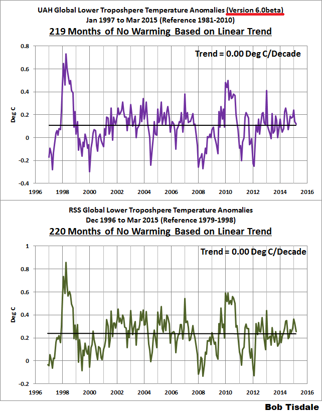
In answer to your question, the difference is in how the signal id pulled out of the noise.
While we are at perhaps you can tell up why the GISS data set which tracked relatively close to the
Satellites from 1979 to 2001, suddenly diverged, about 2002?
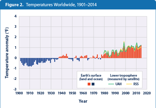
Wood for Trees: Interactive Graphs
 
Perhaps you can ask Christopher Monckton of Brenchley why it is that the same satellites with the same raw data give two different results when analyzed by two different groups.

I'd really, really like to know why that is.

Actually, there's very little difference between RSS and UAH.

The UAH satellite dataset shows a Pause almost as long as the RSS dataset. However, the much-altered surface tamperature datasets show a small warming rate (Fig. 1b).


Last edited:
As opposed to going to a fossil fuel funded think tank for your information?

LOL.

Are you lying again? Forgetting? What?

I don't get my information from such sources. I read peer reviewed papers.
 
Actually, there's very little difference between RSS and UAH.

The UAH satellite dataset shows a Pause almost as long as the RSS dataset. However, the much-altered surface tamperature datasets show a small warming rate (Fig. 1b).


Why do you never look at surface data? As satellites cannot directly measure surface temperatures, and thus every satellite data-set must go throw model based adjustments, it seems as though the "skeptics" would be quite skeptical of satellite data-sets.

Pretty obvious trend when you look at all available datasets. The following is just through 2014, not reflecting the record warmth of 2015:

temperature-figure2-2015.png


I know that in IT, we don't just cherry pick data, but rather look at every metric at our disposal. That is kind of how science works, just not how the denier blogosphere works...
 
Yeah. And then get the analysis from blogs.
Maybe I should put you back on IGNORE. It's pointless trying to reason with you.

You know, the only reason why I took you off IGNORE was because the forum doesn't correctly go to "first unread" when it's an IGNORED user.
 
Why do you never look at surface data? As satellites cannot directly measure surface temperatures, and thus every satellite data-set must go throw model based adjustments, it seems as though the "skeptics" would be quite skeptical of satellite data-sets.

Pretty obvious trend when you look at all available datasets. The following is just through 2014, not reflecting the record warmth of 2015:

temperature-figure2-2015.png


I know that in IT, we don't just cherry pick data, but rather look at every metric at our disposal. That is kind of how science works, just not how the denier blogosphere works...

I was asked a question explicitly and exclusively about satellite temperature records.
 
I was asked a question explicitly and exclusively about satellite temperature records.

Because that is all you want to talk about and ignore everything else. The very definition of cherry picking data.
 
Your post is a non sequitur. Please see #50.

This question was asked in post 50:

Perhaps you can ask Christopher Monckton of Brenchley why it is that the same satellites with the same raw data give two different results when analyzed by two different groups.

I'd really, really like to know why that is.

The reason for this is that satellites don't directly measure temperature, but rather microwaves emitted back into the space and various models are applied to them to approximate temperature from that. They are particularly poor at measuring greenhouse effect warming as that results in less heat being radiated back into the stratosphere and space and more being held at the surface.

This is why its rather ironic for deniers to on one hand criticize climate models yet on the other hand cherry pick data-sets that entirely depend upon models.
 
This question was asked in post 50:


The reason for this is that satellites don't directly measure temperature, but rather microwaves emitted back into the space and various models are applied to them to approximate temperature from that. They are particularly poor at measuring greenhouse effect warming as that results in less heat being radiated back into the stratosphere and space and more being held at the surface.

This is why its rather ironic for deniers to on one hand criticize climate models yet on the other hand cherry pick data-sets that entirely depend upon models.

I discussed satellites because the question was about satellites.
 
...but not the satellite readings.thanks.

Pay no attention to them new-fangledy satellite whatsamajiggers! they aint near as accurate as sparsely situated old fashioned thermometers and some good ole' fashion statistical manipulation, consarnit! *spit*
 
Back
Top Bottom